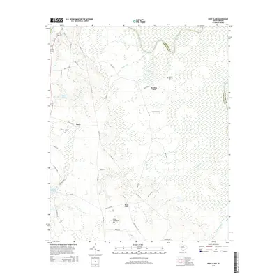
2017 Map of Mont Clare
USGS Topo · Published 2017About this map
The Great Pee Dee River winds through the northeastern reach of this landscape, defining the boundary between Darlington and Marlboro counties. The terrain is characterized by extensive wetlands and Carolina bays, most notably the Devils Woodyard Bay south of the Mont Clare settlement. The road network, including the Society Hill Rd and Mechanicsville Hwy, connects rural communities with deep agricultural roots, as evidenced by family-named landmarks like Robbins Neck and several historic burial grounds.
Find a feature on this map
43 named features on this map. Tap any name to fly to it.
Don’t see what you’re looking for? This feature index may not catch every label — zoom into the map to look around manually.
Map Details
Editions of this 2017 Mont Clare Map
This is the sole edition of this map. No revisions or reprints were ever made.
Other maps of this area

1942 · Rockingham
USGS Topo · 1:125,000

1943 · Gum Swamp
USGS Topo · 1:62,500

1953 · Florence
USGS Topo · 1:250,000

1954 · Florence
USGS Topo · 1:250,000

1963 · Dovesville
USGS Topo · 1:24,000

1963 · Mont Clare
USGS Topo · 1:24,000

1963 · Darlington East
USGS Topo · 1:24,000

1963 · Darlington West
USGS Topo · 1:24,000

1971 · Society Hill
USGS Topo · 1:24,000
1972 · Cash
USGS Topo · 1:24,000