
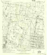
1940 Map of Monte Christo
USGS Topo · Published 1940About this map
The agricultural development of the Rio Grande Valley is visible in this 1940 survey, which highlights the expanding irrigation network of the Main Canal and Shary 3rd Main feeding into local farmsteads. The settlement at Monte Cristo serves as a hub for several family-named ranching operations, including Monte Cristo Ranch, La Gloria Ranch, and Tanquecillas Ranch. The intersection of industrial and social life is evident near Shary Lake, where the Wimobasis Club and an Experimental Farm appear alongside the rail lines of the Missouri Pacific System. This period shows a transition from traditional large-scale ranching to a grid-based agricultural landscape defined by roads such as Mile 10 Road and Mile 9 Road, as well as the extraction efforts at the Joya Gravel Pit.
Find a feature on this map
46 named features on this map. Tap any name to fly to it.
Don’t see what you’re looking for? This feature index may not catch every label — zoom into the map to look around manually.
Map Details
Editions of this 1940 Monte Christo Map
2 editions found
Other maps of this area

1914 · San Juan
USGS Topo · 1:48,000

1916 · San Juan
USGS Topo · 1:62,500

1938 · Sal Colorada
USGS Topo · 1:62,500

1939 · Linn
USGS Topo · 1:62,500

1939 · La Reforma
USGS Topo · 1:62,500

1949 · Mc Allen
USGS Topo · 1:250,000

1954 · McAllen
USGS Topo · 1:250,000

1956 · Garcias
USGS Topo · 1:62,500

1956 · Los Ebanos
USGS Topo · 1:62,500

1957 · Mc Allen
USGS Topo · 1:250,000