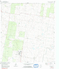
1963 Map of Monte Christo
USGS Topo · Published 1991About this map
Mission Air Base serves as a prominent landmark in this landscape of the Rio Grande Valley, characterized by a complex network of resource extraction and ranching. The Monte Christo Gas Field dominates the central topography, where numerous Gas Wells and an extensive Pipeline system reflect the energy industry's footprint in Hidalgo County during the early 1960s. Rural life is anchored by family-named landmarks such as La Gloria Ranch and isolated water sources like the El Golfo Windmill and La Trenca Windmill. Near the small settlement of Monte Christo, several quarries and a dedicated Picnic Area suggest a mix of industrial utility and local recreation. The presence of a Landing Field near the air base further underscores the importance of aviation to this south Texas region.
Find a feature on this map
15 named features on this map. Tap any name to fly to it.
Don’t see what you’re looking for? This feature index may not catch every label — zoom into the map to look around manually.
Map Details
Editions of this 1963 Monte Christo Map
2 editions found
Other maps of this area

1939 · Linn
USGS Topo · 1:62,500

1939 · La Reforma
USGS Topo · 1:62,500

1940 · Monte Christo
USGS Topo · 1:62,500

1949 · Mc Allen
USGS Topo · 1:250,000

1954 · McAllen
USGS Topo · 1:250,000

1957 · Mc Allen
USGS Topo · 1:250,000

1962 · McAllen
USGS Topo · 1:250,000

1963 · Monte Christo
USGS Topo · 1:24,000

1963 · Edinburg
USGS Topo · 1:24,000
1963 · Faysvillle
USGS Topo · 1:24,000