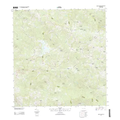
2013 Map of Monte Guilarte
USGS Topo · Published 2013About this map
Monte Guilarte anchors this high-elevation interior landscape where several of the island's major river systems originate. The terrain is a complex network of steep ridges and deep valleys, defining the boundaries between several municipalities including Utuado, Lares, and Adjuntas. The central feature, Lago Guayo, dominates the western portion of the sheet, while the Adjuntas Airport is situated on a relatively rare flat stretch in the east. Numerous family-named roads and trails, such as Camino Damian Rodriguez and Camino Efrain Rivera, provide access to isolated agricultural sectors like Sector Palo Seco and Sector Novillo. The map reveals the intricate drainage patterns of the Rio Tanamá and Rio Yahuccas, showing how the local road network, including PR-128 and PR-135, follows the natural contours of the Central Mountain Range.
Find a feature on this map
100 named features on this map. Tap any name to fly to it.
Don’t see what you’re looking for? This feature index may not catch every label — zoom into the map to look around manually.
Map Details
Editions of this 2013 Monte Guilarte Map
This is the sole edition of this map. No revisions or reprints were ever made.
Other maps of this area

1937 · Sabana Grande
USGS Topo · 1:25,000

1938 · San Sebastian
USGS Topo · 1:20,000

1941 · San Sebastian
USGS Topo · 1:30,000

1941 · Sabana Grande
USGS Topo · 1:30,000

1946 · Maricao
USGS Topo · 1:30,000

1946 · Utuado
USGS Topo · 1:30,000

1946 · Bayaney
USGS Topo · 1:30,000

1946 · Yauco
USGS Topo · 1:30,000

1946 · Monte Guilarte
USGS Topo · 1:30,000

1946 · Penuelas
USGS Topo · 1:30,000
Featured Places
- Sector Jiménez Santiago, Adjuntas
- Sector Lombrices, Adjuntas
- Sector Los Pagán, Adjuntas
- Sector Palo Seco, Adjuntas
- Sector Titulo Quinto, Adjuntas