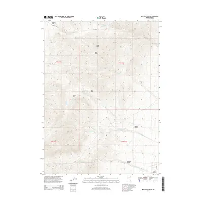
2014 Map of Montello Canyon
USGS Topo · Published 2014About this map
Leach Range defines the high-desert character of this Elko County region, where intricate canyon systems and seasonal water sources dictate the landscape's utility. Significant drainages such as Montello Canyon and Gamble Canyon carve through the terrain, while the presence of Hoppie Basin Spring and Montello Springs highlights the critical importance of water in these arid basins. The map also records the historic path of Twelvemile Cyn and the evocative Immigrant Canyon, names that suggest the movements of early travelers and livestock through these Nevada mountain passes. This 2014 survey documents the enduring physical landmarks of the Great Basin, including Hoppie Basin and various named canyons like Charley Canyon and Kane Canyon, which continue to serve as vital reference points for land management and local navigation in the modern era.
Find a feature on this map
22 named features on this map. Tap any name to fly to it.
Don’t see what you’re looking for? This feature index may not catch every label — zoom into the map to look around manually.
Map Details
Editions of this 2014 Montello Canyon Map
This is the sole edition of this map. No revisions or reprints were ever made.
Other maps of this area

1955 · Wells
USGS Topo · 1:250,000

1958 · Wells
USGS Topo · 1:250,000

1961 · Wells
USGS Topo · 1:250,000

1967 · Valley Pass
USGS Topo · 1:24,000

1967 · Loray
USGS Topo · 1:24,000

1967 · Montello Canyon
USGS Topo · 1:24,000

1967 · Twelvemile Ranch
USGS Topo · 1:24,000

1967 · Montello
USGS Topo · 1:24,000

1967 · Ninemile Mtn NE
USGS Topo · 1:24,000
1967 · Pilot Peak NW
USGS Topo · 1:24,000