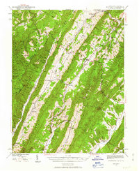
1941 Map of Monterey
USGS Topo · Published 1963About this map
Monterey serves as the central hub of this Highland County landscape, where the Parkersburg and Staunton Pike cuts through the dramatic ridges of the Appalachian Mountains. Surveyed in the early 1940s, the map reveals a deeply rural pattern of life organized around narrow valleys and mountain gaps. Small upland communities like New Hampden, Blue Grass, and Hightown are connected by winding roads like Dug Road, while local education and faith are anchored by numerous landmarks such as the Strait Creek Sch, Thorny Bottom Ch, and Woods-Terry Sch. The terrain is defined by massive parallel ridges, including Lantz Mountain and Jack Mountain, which separate the headwaters of the South Branch Potomac River from the Jackson River. This survey captures the region as it transitions between the Monongahela National Forest and George Washington National Forest, preserving the names of family landmarks like the Griffin Cem and Hevener Run before modern development altered these mountain corridors.
Find a feature on this map
85 named features on this map. Tap any name to fly to it.
Don’t see what you’re looking for? This feature index may not catch every label — zoom into the map to look around manually.
Map Details
Editions of this 1941 Monterey Map
2 editions found

Other maps of this area

1889 · Beverly
USGS Topo · 1:125,000

1892 · Beverly
USGS Topo · 1:125,000

1892 · Franklin
USGS Topo · 1:125,000

1894 · Staunton
USGS Topo · 1:125,000

1896 · Franklin
USGS Topo · 1:125,000

1901 · Monterey
USGS Topo · 1:125,000

1922 · Spruce Knob
USGS Topo · 1:48,000

1922 · Cass
USGS Topo · 1:48,000

1922 · Durbin
USGS Topo · 1:48,000

1922 · Circleville
USGS Topo · 1:62,500