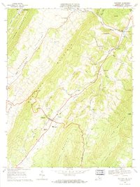
1969 Map of Monterey
USGS Topo · Published 1971About this map
Monterey serves as the focal point of this Highland County landscape, situated where the road network converges between the massive ridges of Monterey Mountain and Jack Mountain. The late 1960s geography reflects a rural community anchored by small settlements like Blue Grass and New Hampden, while local institutions such as Highland High School and Asbury Church mark the social centers of the valleys.
Find a feature on this map
43 named features on this map. Tap any name to fly to it.
Don’t see what you’re looking for? This feature index may not catch every label — zoom into the map to look around manually.
Map Details
Editions of this 1969 Monterey Map
3 editions found
Other maps of this area

1889 · Beverly
USGS Topo · 1:125,000

1892 · Beverly
USGS Topo · 1:125,000

1892 · Franklin
USGS Topo · 1:125,000

1894 · Staunton
USGS Topo · 1:125,000

1896 · Franklin
USGS Topo · 1:125,000

1901 · Monterey
USGS Topo · 1:125,000

1922 · Spruce Knob
USGS Topo · 1:48,000

1922 · Circleville
USGS Topo · 1:62,500

1924 · Circleville
USGS Topo · 1:48,000

1924 · Mc Dowell
USGS Topo · 1:62,500