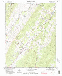
1969 Map of Monterey
USGS Topo · Published 1989About this map
Monterey serves as the focal point of this Highland County landscape, situated at the base of Monterey Mountain where the headwaters of the South Branch Potomac River begin their northern descent. The topography is dominated by parallel ridges including Lantz Mountain and Jack Mountain, which dictate the linear settlement patterns of communities like Blue Grass and New Hampden. This 1960s perspective captures a distinct rural infrastructure, from the Highland High School and Hannah Airfield near the town center to the Fish Hatchery and Drive-in Theater farther north along the Potomac valley.
Find a feature on this map
46 named features on this map. Tap any name to fly to it.
Don’t see what you’re looking for? This feature index may not catch every label — zoom into the map to look around manually.
Map Details
Editions of this 1969 Monterey Map
3 editions found
Other maps of this area

1889 · Beverly
USGS Topo · 1:125,000

1892 · Beverly
USGS Topo · 1:125,000

1892 · Franklin
USGS Topo · 1:125,000

1894 · Staunton
USGS Topo · 1:125,000

1896 · Franklin
USGS Topo · 1:125,000

1901 · Monterey
USGS Topo · 1:125,000

1922 · Spruce Knob
USGS Topo · 1:48,000

1922 · Circleville
USGS Topo · 1:62,500

1924 · Circleville
USGS Topo · 1:48,000

1924 · Mc Dowell
USGS Topo · 1:62,500