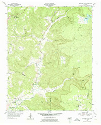
1956 Map of Monterey Lake
USGS Topo · Published 1975About this map
The Calfkiller River carves a winding path through the heart of this landscape, marking the rugged transition between the plateaus and deep coves of the Putnam Co White Co border. In the mid-1950s, this region was defined by small, family-centered settlements and rural institutions like Big Spring Ch and the nearby Big Spring Sch. The map illustrates the concentration of community life along the river valley and its tributaries, including Cove Creek and Mill Creek. To the northeast, Monterey Lake and Camp Monterey stand as established landmarks, while the surrounding terrain is deeply etched by named hollows such as Verble Hollow and Stamps Hollow. This survey provides a vital record for those tracing local lineages through the numerous family burial grounds, including the Henry Cem and Crouse Cem, which are situated near old crossroads and early mountain schools like Robinson Sch.
Find a feature on this map
40 named features on this map. Tap any name to fly to it.
Don’t see what you’re looking for? This feature index may not catch every label — zoom into the map to look around manually.
Map Details
Editions of this 1956 Monterey Lake Map
3 editions found
Other maps of this area

1892 · Pikeville
USGS Topo · 1:125,000

1895 · Pikeville
USGS Topo · 1:125,000

1897 · Standingstone
USGS Topo · 1:125,000

1898 · Standingstone
USGS Topo · 1:125,000

1912 · Crossville
USGS Topo · 1:62,500

1935 · Campbell Junction
USGS Topo · 1:24,000

1943 · Cookeville
USGS Topo · 1:100,000

1944 · Cookeville
USGS Topo · 1:100,000

1946 · Campbell Junction
USGS Topo · 1:24,000

1946 · Obey City
USGS Topo · 1:24,000