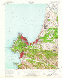
1947 Map of Monterey
USGS Topo · Published 1963About this map
Monterey and the surrounding peninsula show a landscape shaped by military presence and early California history just after World War II. The Fort Ord Military Reservation dominates the northern coast, featuring extensive infrastructure such as a Parade Ground, Target Range, and various training areas like Artillery Hill. To the south, the historic ecclesiastical roots of the region are preserved at the Mission San Carlos Borromeo and the Carmelite Mission near the mouth of the Carmel River.
Find a feature on this map
99 named features on this map. Tap any name to fly to it.
Don’t see what you’re looking for? This feature index may not catch every label — zoom into the map to look around manually.
Map Details
Editions of this 1947 Monterey Map
4 editions found

Other maps of this area

1910 · Salinas
USGS Topo · 1:31,680

1912 · Salinas
USGS Topo · 1:62,500

1912 · Capitola
USGS Topo · 1:62,500

1913 · Monterey
USGS Topo · 1:62,500

1914 · Capitola
USGS Topo · 1:62,500

1915 · San Juan Bautista
USGS Topo · 1:48,000

1917 · San Juan Bautista
USGS Topo · 1:62,500

1918 · Point Sur
USGS Topo · 1:62,500

1920 · Jamesburg
USGS Topo · 1:48,000

1921 · Jamesburg
USGS Topo · 1:62,500