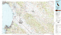
1983 Map of Monterey
USGS Topo · Published 1984About this map
The Salinas River valley and the dramatic coastline of Monterey Bay dominate this 1983 survey, showcasing the region's complex mix of military, agricultural, and preserved lands. The expansive Fort Ord Military Reservation sits prominently between Marina and the city of Salinas, while the historic Mission San Juan Bautista serves as a landmark for the inland settlement of San Juan Bautista. The landscape is a study in diverse geography, from the marshes of Elkhorn Slough at Moss Landing to the high peaks of the Gabilan Range.
Find a feature on this map
197 named features on this map. Tap any name to fly to it.
Don’t see what you’re looking for? This feature index may not catch every label — zoom into the map to look around manually.
Map Details
Editions of this 1983 Monterey Map
2 editions found
Other maps of this area

1902 · Santa Cruz
USGS Topo · 1:125,000

1910 · Gonzales
USGS Topo · 1:31,680

1910 · Salinas
USGS Topo · 1:31,680

1910 · Soledad
USGS Topo · 1:31,680

1912 · Salinas
USGS Topo · 1:62,500

1912 · Capitola
USGS Topo · 1:62,500

1913 · Monterey
USGS Topo · 1:62,500

1913 · Panoche
USGS Topo · 1:125,000

1914 · Capitola
USGS Topo · 1:62,500

1915 · Soledad
USGS Topo · 1:62,500