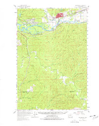
1955 Map of Montesano
USGS Topo · Published 1978About this map
Montesano serves as the focal point of this mid-century survey, situated at the confluence of the Chehalis River and the Wynoochee River. The landscape is defined by the shifting waters of the Chehalis, where various channels like Chuck Slough, Preachers Slough, and Blue Slough navigate around Sand Island and Higgins Island. To the east, the Sylvia Lake State Park and Sylvia Lake offer a glimpse into the region's recreational development alongside industrial markers like several Gravel Pit sites and a Quarry.
Find a feature on this map
62 named features on this map. Tap any name to fly to it.
Don’t see what you’re looking for? This feature index may not catch every label — zoom into the map to look around manually.
Map Details
Editions of this 1955 Montesano Map
3 editions found

Other maps of this area

1938 · South Bend
USGS Topo · 1:62,500

1940 · Montesano
USGS Topo · 1:62,500

1940 · South Bend
USGS Topo · 1:62,500

1941 · Walville
USGS Topo · 1:62,500

1941 · Mobray
USGS Topo · 1:62,500

1941 · Ford
USGS Topo · 1:62,500

1943 · Humptulips
USGS Topo · 1:62,500

1943 · Nahwatzel Lake
USGS Topo · 1:62,500

1943 · Mobray
USGS Topo · 1:62,500

1953 · Hoquiam
USGS Topo · 1:250,000