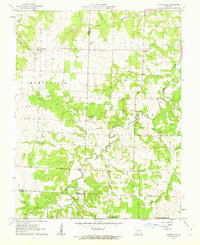
1962 Map of Montevallo
USGS Topo · Published 1963About this map
Montevallo and the surrounding borderlands of Cedar, Vernon, and Barton counties define this early 1960s landscape. The settlement of Olympia sits to the east, while the rural topography is carved by a dense network of waterways including Stinking Creek, Hicklin Creek, and Horse Creek. State Geologist Thomas R. Beveridge oversaw this survey, which captures the region's agricultural and social foundations through its scattered country churches and family burial grounds. Notable landmarks for local historians include Glade Springs Ch and several well-maintained cemeteries like Walnut Grove Cem and Oldham Cem. Small-scale industrial activity is evidenced by a Quarry located near the junction of Tom Branch and Horse Creek, reflecting the local resource extraction of the era before the shift toward more modern land-use patterns in southwest Missouri.
Find a feature on this map
26 named features on this map. Tap any name to fly to it.
Don’t see what you’re looking for? This feature index may not catch every label — zoom into the map to look around manually.
Map Details
Editions of this 1962 Montevallo Map
2 editions found
Other maps of this area

1886 · Nevada
USGS Topo · 1:125,000

1886 · Stockton
USGS Topo · 1:125,000

1894 · Nevada
USGS Topo · 1:125,000

1939 · Dederick
USGS Topo · 1:24,000

1939 · Filley
USGS Topo · 1:24,000

1939 · Eldorado Springs South
USGS Topo · 1:24,000

1940 · Filley
USGS Topo · 1:24,000
1942 · Dederick
USGS Topo · 1:24,000
1942 · Eldorado Springs South
USGS Topo · 1:24,000

1947 · Joplin
USGS Topo · 1:250,000