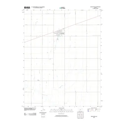
2009 Map of Montezuma
USGS Topo · Published 2009About this map
Montezuma sits at the heart of this Gray County landscape, where the town's street grid, including W Sunnyside Ave and E Texcoco St, breaks the expansive geometry of the surrounding section roads. This 2009 survey illustrates a classic High Plains settlement pattern, where long, straight thoroughfares like A A Rd and H H Rd organize the agricultural territory into a precise network of large-scale farming parcels. The drainage patterns of several intermittent creeks flow southward through these plots, providing a natural contrast to the rigid human-made infrastructure. Located well south of the town center, Evans Cemetery stands as a quiet landmark along G G Rd, serving as a primary point of interest for those researching local family history and rural burial sites in this part of Kansas.
Find a feature on this map
20 named features on this map. Tap any name to fly to it.
Don’t see what you’re looking for? This feature index may not catch every label — zoom into the map to look around manually.
Map Details
Editions of this 2009 Montezuma Map
This is the sole edition of this map. No revisions or reprints were ever made.
Other maps of this area

1892 · Meade
USGS Topo · 1:125,000

1892 · Dodge
USGS Topo · 1:125,000

1896 · Garden
USGS Topo · 1:125,000

1955 · Dodge City
USGS Topo · 1:250,000

1958 · Dodge City
USGS Topo · 1:250,000

1959 · Dodge City
USGS Topo · 1:250,000

1967 · Plains NE
USGS Topo · 1:24,000

1968 · Montezuma
USGS Topo · 1:24,000

1968 · Montezuma NW
USGS Topo · 1:24,000
1968 · Meade NW
USGS Topo · 1:24,000