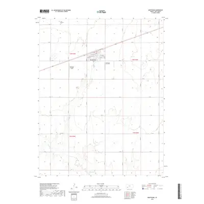
2018 Map of Montezuma
USGS Topo · Published 2018About this map
Montezuma serves as the central hub of this agricultural landscape in Gray County, where a grid of rural roads connects scattered farmsteads and local landmarks. The town's street plan features locally distinctive names such as E Texcoco St, W Sunnyside Ave, and E Clifton Ave. Aviation is integral to the local economy and transport, evidenced by both the Montezuma Municipal Airport and the Montezuma Coop Airport. To the south, the terrain becomes more varied as it descends toward the banks of Crooked Cr. For those tracing local heritage, the map identifies significant burial sites including North Mennonite Cem to the north and Evans Cem situated along the creek. This survey reveals a community deeply rooted in its traditional township divisions, specifically t28s r29w and t29s r29w, maintaining its character through a well-defined network of rural delivery routes.
Find a feature on this map
32 named features on this map. Tap any name to fly to it.
Don’t see what you’re looking for? This feature index may not catch every label — zoom into the map to look around manually.
Map Details
Editions of this 2018 Montezuma Map
This is the sole edition of this map. No revisions or reprints were ever made.
Other maps of this area

1892 · Meade
USGS Topo · 1:125,000

1892 · Dodge
USGS Topo · 1:125,000

1896 · Garden
USGS Topo · 1:125,000

1955 · Dodge City
USGS Topo · 1:250,000

1958 · Dodge City
USGS Topo · 1:250,000

1959 · Dodge City
USGS Topo · 1:250,000

1967 · Plains NE
USGS Topo · 1:24,000

1968 · Montezuma
USGS Topo · 1:24,000

1968 · Montezuma NW
USGS Topo · 1:24,000
1968 · Meade NW
USGS Topo · 1:24,000