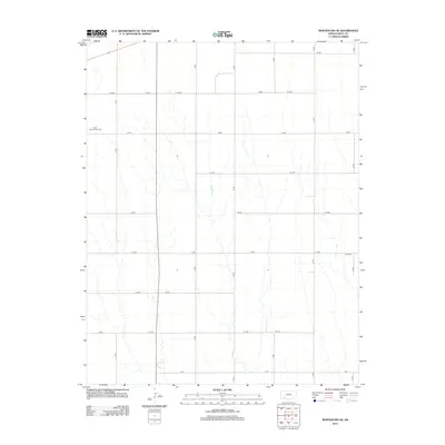
2012 Map of Montezuma SE
USGS Topo · Published 2012About this map
The Gray County Wind Farm occupies the northwest portion of this Kansas landscape, reflecting the modern intersection of agricultural land and renewable energy production. This quadrangle in Gray County is defined by a strictly organized section-line grid, where roads like AA Rd and II Rd frame a series of ephemeral drainages that flow south toward the Cimarron River basin. Aside from the utility-scale wind infrastructure, the landscape is largely open and rural, punctuated by a single historic site, the Cave Cem, located in the eastern portion of the map. The persistence of the township-and-range survey system is evident in the naming conventions of the secondary road network, which uses an alphanumeric system to navigate the high plains.
Find a feature on this map
20 named features on this map. Tap any name to fly to it.
Don’t see what you’re looking for? This feature index may not catch every label — zoom into the map to look around manually.
Map Details
Editions of this 2012 Montezuma SE Map
This is the sole edition of this map. No revisions or reprints were ever made.
Other maps of this area

1892 · Meade
USGS Topo · 1:125,000

1892 · Dodge
USGS Topo · 1:125,000

1955 · Dodge City
USGS Topo · 1:250,000

1958 · Dodge City
USGS Topo · 1:250,000

1959 · Dodge City
USGS Topo · 1:250,000

1968 · Montezuma
USGS Topo · 1:24,000

1968 · Montezuma NW
USGS Topo · 1:24,000
1968 · Meade NW
USGS Topo · 1:24,000

1969 · Meade NE
USGS Topo · 1:24,000
1969 · Fowler
USGS Topo · 1:24,000