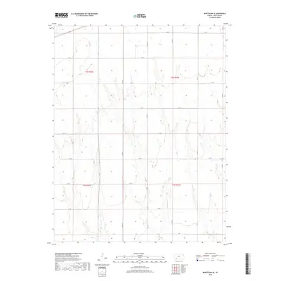
2018 Map of Montezuma SE
USGS Topo · Published 2018About this map
Cave Cem sits on the eastern edge of this Gray County landscape, a small but significant landmark in a region defined by its precise agrarian organization. The terrain is divided into a strict grid by rural routes such as Co Rd 20, Co Rd 21, and Co Rd 22, which intersect with alphabetically named corridors like A A Rd and B B Rd. These survey lines, managed under the Public Land Survey System across t28s r27w and t29s r27w, show how the high plains were segmented for settlement and agricultural use. While the map is dominated by these man-made boundaries, the subtle contour lines reveal the natural drainage patterns that break the geometric regularity of the section lines.
Find a feature on this map
19 named features on this map. Tap any name to fly to it.
Don’t see what you’re looking for? This feature index may not catch every label — zoom into the map to look around manually.
Map Details
Editions of this 2018 Montezuma SE Map
This is the sole edition of this map. No revisions or reprints were ever made.
Other maps of this area

1892 · Meade
USGS Topo · 1:125,000

1892 · Dodge
USGS Topo · 1:125,000

1955 · Dodge City
USGS Topo · 1:250,000

1958 · Dodge City
USGS Topo · 1:250,000

1959 · Dodge City
USGS Topo · 1:250,000

1968 · Montezuma
USGS Topo · 1:24,000

1968 · Montezuma NW
USGS Topo · 1:24,000
1968 · Meade NW
USGS Topo · 1:24,000

1969 · Meade NE
USGS Topo · 1:24,000
1969 · Fowler
USGS Topo · 1:24,000