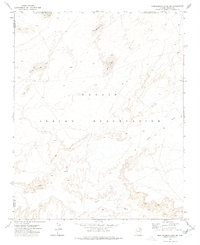
1972 Map of Montezumas Chair NW
USGS Topo · Published 1975About this map
The Navajo Indian Reservation landscape is defined by vast Sand Dunes and ephemeral water systems in this 1972 field-checked survey. The terrain is marked by the winding paths of Jadito Wash and Coyote Wash, which cut through the arid high desert. Isolated indicators of human infrastructure are sparse, appearing primarily as a Well and a labeled Wt (water tank), reflecting the critical importance of water management in this region of the Navajo Indian Reservation Boundary. The map also delineates the Coconino Co Navajo Co line and the Joint Use Area Boundary, capturing the administrative and tribal divisions of the era. This document preserves the exact topography of the Navajo lands before later shifts in land use and boundary designations.
Find a feature on this map
8 named features on this map. Tap any name to fly to it.
Don’t see what you’re looking for? This feature index may not catch every label — zoom into the map to look around manually.
Map Details
Editions of this 1972 Montezumas Chair NW Map
This is the sole edition of this map. No revisions or reprints were ever made.
Other maps of this area

1883 · Tusayan
USGS Topo · 1:250,000

1886 · Tusayan
USGS Topo · 1:250,000

1947 · Flagstaff
USGS Topo · 1:250,000

1954 · Flagstaff
USGS Topo · 1:250,000

1955 · Leupp
USGS Topo · 1:62,500

1957 · Winslow 1 SW
USGS Topo · 1:24,000
1957 · Winslow 2 SE
USGS Topo · 1:24,000

1958 · Flagstaff
USGS Topo · 1:250,000

1960 · Flagstaff
USGS Topo · 1:250,000

1962 · Flagstaff
USGS Topo · 1:250,000