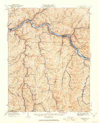
1928 Map of Montgomery
USGS Topo · Published 1963About this map
The Kanawha River serves as the industrial spine for this coal-rich region, where the Chesapeake and Ohio and Kanawha and Michigan railroads parallel the water. The landscape is defined by deep hollows and narrow creek beds, such as Witcher Creek and Armstrong Creek, which provided the geography for dozens of small mining and industrial settlements. A notable industrial landmark is the Pure Oil Refinery near Cabin Creek Junction, illustrating the area's transition into oil processing alongside its coal heritage.
Find a feature on this map
154 named features on this map. Tap any name to fly to it.
Don’t see what you’re looking for? This feature index may not catch every label — zoom into the map to look around manually.
Map Details
Editions of this 1928 Montgomery Map
This is the sole edition of this map. No revisions or reprints were ever made.
Other maps of this area

1891 · Oceana
USGS Topo · 1:125,000

1891 · Raleigh
USGS Topo · 1:125,000

1893 · Oceana
USGS Topo · 1:125,000

1897 · Kanawha Falls
USGS Topo · 1:125,000

1897 · Raleigh
USGS Topo · 1:125,000

1898 · Oceana
USGS Topo · 1:125,000

1899 · Charleston
USGS Topo · 1:125,000

1900 · Kanawha Falls
USGS Topo · 1:125,000

1901 · Kanawha Falls
USGS Topo · 1:125,000

1902 · Raleigh
USGS Topo · 1:125,000