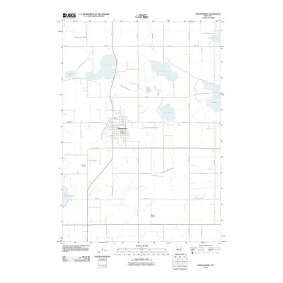
2010 Map of Montgomery
USGS Topo · Published 2010About this map
Montgomery serves as the central hub of this agricultural landscape in Le Sueur County, defined by a series of glacial lakes and an extensive drainage network. The town's layout is anchored by the Montgomery Post Office, with the surrounding countryside reflecting its immigrant heritage through landmarks like the Bohemian Cemetery and Saint Michael Cemetery. The hydrology of the area is heavily managed, as evidenced by numerous engineered waterways including County Ditch Number Fortyfour and County Ditch Number Thirty, which crisscross the till plain between natural basins such as Lake Pepin and Lake Sanborn. This 2010 survey illustrates the modern road grid, including Lexington Rd and County Hwy-26, which facilitates the region's farming economy while skirting the edges of Rice Lake and Phelps Lake.
Find a feature on this map
54 named features on this map. Tap any name to fly to it.
Don’t see what you’re looking for? This feature index may not catch every label — zoom into the map to look around manually.
Map Details
Editions of this 2010 Montgomery Map
This is the sole edition of this map. No revisions or reprints were ever made.
Other maps of this area

1953 · Saint Paul
USGS Topo · 1:250,000

1957 · Prior Lake
USGS Topo · 1:62,500

1957 · New Prague
USGS Topo · 1:62,500

1959 · Saint Paul
USGS Topo · 1:250,000

1960 · Shieldsville
USGS Topo · 1:24,000

1960 · Lonsdale
USGS Topo · 1:24,000

1966 · Montgomery
USGS Topo · 1:24,000

1966 · Cordova
USGS Topo · 1:24,000

1966 · Le Center
USGS Topo · 1:24,000
1966 · Kilkenny
USGS Topo · 1:24,000