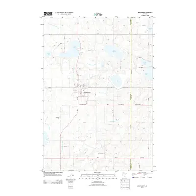
2013 Map of Montgomery
USGS Topo · Published 2013About this map
Montgomery serves as the central hub of this agricultural and lake-rich landscape along the Le Sueur Co and Rice Co line. The settlement pattern is defined by a dense network of country roads and county ditches, such as County Ditch Number Thirty and County Ditch Number Eighteen, which manage the drainage of the area's numerous glacial basins. Notable water bodies including Lake Pepin, Lake Sanborn, and Rice Lake dot the northern and central sections, reflecting the typical pothole topography of the region.
Find a feature on this map
66 named features on this map. Tap any name to fly to it.
Don’t see what you’re looking for? This feature index may not catch every label — zoom into the map to look around manually.
Map Details
Editions of this 2013 Montgomery Map
This is the sole edition of this map. No revisions or reprints were ever made.
Other maps of this area

1953 · Saint Paul
USGS Topo · 1:250,000

1957 · Prior Lake
USGS Topo · 1:62,500

1957 · New Prague
USGS Topo · 1:62,500

1959 · Saint Paul
USGS Topo · 1:250,000

1960 · Shieldsville
USGS Topo · 1:24,000

1960 · Lonsdale
USGS Topo · 1:24,000

1966 · Montgomery
USGS Topo · 1:24,000

1966 · Cordova
USGS Topo · 1:24,000

1966 · Le Center
USGS Topo · 1:24,000
1966 · Kilkenny
USGS Topo · 1:24,000