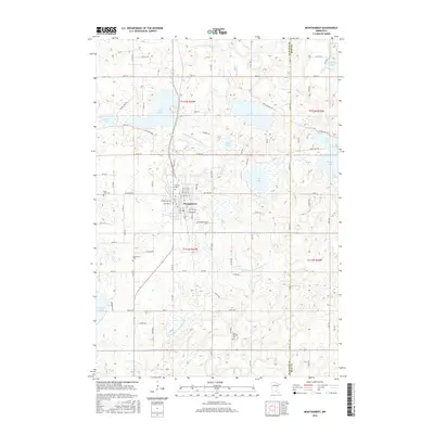
2016 Map of Montgomery
USGS Topo · Published 2016About this map
Montgomery anchors this agricultural landscape in the Minnesota lake country, serving as a hub where the street grid of Spruce Ave NW and Vine Ave W meets the rural county roads. The territory is defined by a dense network of glacial basins and engineered waterways, including the winding County Ditch Number Thirty and County Ditch Number Eighteen. These drainage systems reveal the mid-century transformation of the wetland terrain into productive farmland, though prominent bodies of water like Lake Sanborn, Lake Pepin, and Rice Lake remain central features of the local topography.
Find a feature on this map
62 named features on this map. Tap any name to fly to it.
Don’t see what you’re looking for? This feature index may not catch every label — zoom into the map to look around manually.
Map Details
Editions of this 2016 Montgomery Map
This is the sole edition of this map. No revisions or reprints were ever made.
Other maps of this area

1953 · Saint Paul
USGS Topo · 1:250,000

1957 · Prior Lake
USGS Topo · 1:62,500

1957 · New Prague
USGS Topo · 1:62,500

1959 · Saint Paul
USGS Topo · 1:250,000

1960 · Shieldsville
USGS Topo · 1:24,000

1960 · Lonsdale
USGS Topo · 1:24,000

1966 · Montgomery
USGS Topo · 1:24,000

1966 · Cordova
USGS Topo · 1:24,000

1966 · Le Center
USGS Topo · 1:24,000
1966 · Kilkenny
USGS Topo · 1:24,000