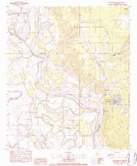
1983 Map of Montgomery
USGS Topo · Published 1984About this map
Montgomery sits as a central hub on the eastern bluffs overlooking the shifting course of the Red River in this early 1980s survey. The landscape is defined by the complex hydrology of the Red River valley, where numerous oxbows and secondary channels like Little River and Cane River Lake create a network of bottomlands and ridges. The Kansas City Southern railroad serves as a primary transit corridor, connecting the smaller settlements of Crews and Kadesh through the timbered reaches of the Kisatchie National Forest. Local community life is rooted in a dense distribution of country churches and schools, including New Salem Ch, Pleasant Hill Ch, and the Gaines Jr High Sch, reflecting the established social fabric of Grant and Natchitoches Parishes during this era.
Find a feature on this map
43 named features on this map. Tap any name to fly to it.
Don’t see what you’re looking for? This feature index may not catch every label — zoom into the map to look around manually.
Map Details
Editions of this 1983 Montgomery Map
2 editions found
Other maps of this area

1935 · Verda
USGS Topo · 1:31,680

1937 · Bermuda
USGS Topo · 1:31,680

1937 · Campti SE
USGS Topo · 1:31,680

1937 · Aloha
USGS Topo · 1:31,680

1937 · Montgomery
USGS Topo · 1:62,500

1937 · Cloutierville
USGS Topo · 1:31,680

1937 · Cypress
USGS Topo · 1:31,680

1942 · Montgomery
USGS Topo · 1:62,500

1943 · Provencal
USGS Topo · 1:62,500

1944 · Campti
USGS Topo · 1:62,500