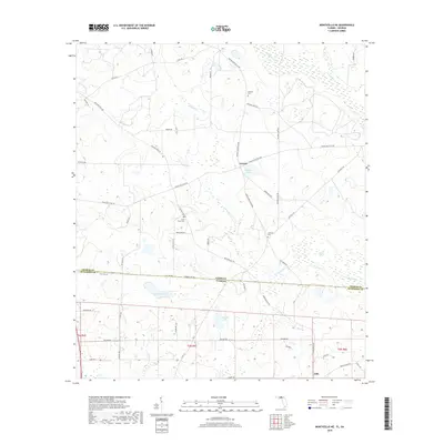
2018 Map of Monticello NE
USGS Topo · Published 2018About this map
The Georgia-Florida border cuts across this landscape, dividing Thomas County and Jefferson County along a line of rural road networks. In Georgia, the settlement of Everett serves as a local hub near Madre Pond, while the southern portion of the map in Florida reaches down to Dills. The terrain is defined by low-lying wetlands and significant water bodies, including the upper reaches of the Aucilla River and the winding course of Connell Creek. Genealogists will find several family-named landmarks and burial sites throughout the area, such as Mallette Cemetery and Laffittee Cemetery. The road system is remarkably dense for a rural area, with numerous named routes like Twelve Mile Post Road and Reichertville Road connecting scattered farmsteads and crossing the state line.
Find a feature on this map
53 named features on this map. Tap any name to fly to it.
Don’t see what you’re looking for? This feature index may not catch every label — zoom into the map to look around manually.
Map Details
Editions of this 2018 Monticello NE Map
This is the sole edition of this map. No revisions or reprints were ever made.
Other maps of this area

1954 · Valdosta
USGS Topo · 1:250,000

1956 · Grooverville
USGS Topo · 1:24,000

1956 · Monticello NE
USGS Topo · 1:24,000

1956 · Metcalf
USGS Topo · 1:24,000

1957 · Thomasville
USGS Topo · 1:62,500

1958 · Valdosta
USGS Topo · 1:250,000

1959 · Valdosta
USGS Topo · 1:250,000

1961 · Quitman
USGS Topo · 1:62,500

1962 · Ashville
USGS Topo · 1:24,000
1963 · Lake Miccosukee
USGS Topo · 1:24,000