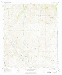
1961 Map of Monticello
USGS Topo · Published 1975About this map
Monticello and the nearby village of Placitas sit at the center of this 1961 field-checked survey of New Mexico's high desert. The landscape is defined by the canyon network of Alamosa Creek, where agricultural life is sustained by the Community Ditch. Local landmarks including St Ignatius Ch and the Monticello Cem anchor the community, while the Rodeo Ground hints at the area's ranching culture. To the north, the boundary between Socorro and Sierra counties cuts through the Cibola National Forest. The map details numerous water sources essential to this arid environment, from the Shipman Well and Stanley Spring to livestock-focused points like Bill Tank and Jose Maria Well. High points such as Seferino Hill and Fifty-fifty Hill overlook a complex system of draws and canyons, including the prominent Monticello Canyon.
Find a feature on this map
61 named features on this map. Tap any name to fly to it.
Don’t see what you’re looking for? This feature index may not catch every label — zoom into the map to look around manually.
Map Details
Editions of this 1961 Monticello Map
2 editions found
Other maps of this area

1954 · Tularosa
USGS Topo · 1:250,000

1958 · Tularosa
USGS Topo · 1:250,000

1961 · Priest Tank
USGS Topo · 1:24,000

1961 · Huerfano Hill
USGS Topo · 1:24,000

1961 · Sierra Fijardo
USGS Topo · 1:24,000

1961 · Monticello
USGS Topo · 1:24,000

1964 · Vicks Peak
USGS Topo · 1:24,000

1964 · Montoya Butte
USGS Topo · 1:24,000

1964 · Steel Hill
USGS Topo · 1:24,000

1965 · Jaralosa Mountain
USGS Topo · 1:24,000