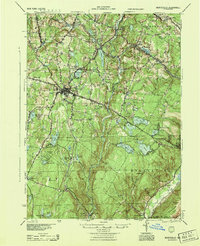
1944 Map of Monticello
USGS Topo · Published 1944About this map
The village of Monticello serves as a central hub in this mid-century portrait of Sullivan County, situated at the intersection of the historic Newburgh and Cochecton Road and several secondary arteries. The landscape is defined by the winding course of the Neversink River and an extensive network of water bodies, including Kiamesha Lake and Sackett Lake. To the south and west, the territory becomes more forested, home to established retreats like the Hartwood Club and the residential clusters of Merriewold Park and Mamakating Park.
Find a feature on this map
67 named features on this map. Tap any name to fly to it.
Don’t see what you’re looking for? This feature index may not catch every label — zoom into the map to look around manually.
Map Details
Editions of this 1944 Monticello Map
This is the sole edition of this map. No revisions or reprints were ever made.
Other maps of this area

1903 · Slide Mountain
USGS Topo · 1:62,500

1904 · Ellenville
USGS Topo · 1:62,500

1905 · Slide Mountain
USGS Topo · 1:62,500

1906 · Ellenville
USGS Topo · 1:62,500

1906 · Port Jervis
USGS Topo · 1:62,500

1906 · Goshen
USGS Topo · 1:62,500

1908 · Goshen
USGS Topo · 1:62,500

1908 · Port Jervis
USGS Topo · 1:62,500

1909 · Monticello
USGS Topo · 1:62,500

1910 · Neversink
USGS Topo · 1:62,500