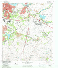
1988 Map of Montopolis
USGS Topo · Published 1988About this map
The Colorado River meanders across this late 1980s landscape, marking the transition from the growing urban core of Austin to the rural communities of southeast Travis County. A massive industrial and military presence is established at Bergstrom Air Force Base, which dominates the central portion of the sheet. To the north, the historic neighborhood of Montopolis is shown with its density of schools like Dolores Sch and Allison Sch, reflecting a settled residential community just west of the river's great curve at Hornsby Bend.
Find a feature on this map
62 named features on this map. Tap any name to fly to it.
Don’t see what you’re looking for? This feature index may not catch every label — zoom into the map to look around manually.
Map Details
Editions of this 1988 Montopolis Map
This is the sole edition of this map. No revisions or reprints were ever made.
Other maps of this area

1896 · Austin
USGS Topo · 1:125,000

1897 · Austin
USGS Topo · 1:125,000

1910 · Austin
USGS Topo · 1:125,000

1932 · Mt. Bonnell
USGS Topo · 1:62,500

1954 · Austin East
USGS Topo · 1:24,000

1954 · Austin West
USGS Topo · 1:24,000

1954 · Austin
USGS Topo · 1:250,000

1955 · Montopolis
USGS Topo · 1:24,000

1955 · Oak Hill
USGS Topo · 1:24,000

1955 · Montopolis
USGS Topo · 1:62,500