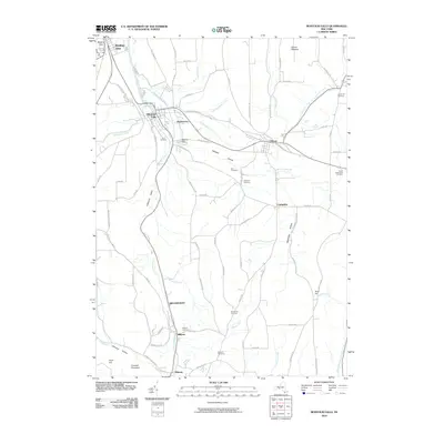
2010 Map of Montour Falls
USGS Topo · Published 2010About this map
Watkins Glen and the village of Montour Falls anchor this landscape at the southern tip of the Finger Lakes region. The terrain is defined by deep north-south valleys, where Catharine Creek and its tributaries have carved significant features into the local topography, including Shequaga Falls and Aunt Sarahs Falls. This survey documents a rural and village network connected by local routes like Rock Cabin Rd and Frost Hill Rd, serving a series of small, long-established settlements such as Odessa, Millport, and Catharine. For the genealogist and local historian, the map identifies numerous family and community burial grounds, from the Laurel Hill Cemetery in the northeast to the Parsons Cemetery near the southern border. The transition between the high ground of Crandall Mountain and the deep hollows like Mitchell Hollow illustrates the drainage patterns that shaped early development in Schuyler and Chemung Counties.
Find a feature on this map
90 named features on this map. Tap any name to fly to it.
Don’t see what you’re looking for? This feature index may not catch every label — zoom into the map to look around manually.
Map Details
Editions of this 2010 Montour Falls Map
This is the sole edition of this map. No revisions or reprints were ever made.
Other maps of this area

1893 · Ithaca
USGS Topo · 1:62,500

1895 · Ithaca
USGS Topo · 1:62,500

1895 · Elmira
USGS Topo · 1:62,500

1898 · Watkins Glen
USGS Topo · 1:62,500

1901 · Watkins
USGS Topo · 1:62,500

1902 · Waverly
USGS Topo · 1:62,500

1905 · Watkins Glen
USGS Topo · 1:125,000

1950 · Elmira
USGS Topo · 1:250,000

1950 · Alpine
USGS Topo · 1:24,000
1950 · Burdett
USGS Topo · 1:24,000