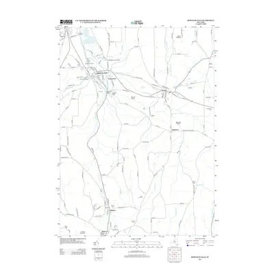
2013 Map of Montour Falls
USGS Topo · Published 2013About this map
Montour Falls serves as the focal point of this Schuyler County landscape, where the waters of Catharine Cr and Shequaga Cr converge. The topography is defined by significant elevation changes, notably at Shequaga Falls and Aunt Sarahs Falls, which emphasize the dramatic descent into the valley floor. The village center is linked by several structures, including the Mill Street Bridge and the Lhommedieu Street Bridge, spanning the intricate network of creeks and the Diversion Channel.
Find a feature on this map
143 named features on this map. Tap any name to fly to it.
Don’t see what you’re looking for? This feature index may not catch every label — zoom into the map to look around manually.
Map Details
Editions of this 2013 Montour Falls Map
This is the sole edition of this map. No revisions or reprints were ever made.
Other maps of this area

1893 · Ithaca
USGS Topo · 1:62,500

1895 · Ithaca
USGS Topo · 1:62,500

1895 · Elmira
USGS Topo · 1:62,500

1898 · Watkins Glen
USGS Topo · 1:62,500

1901 · Watkins
USGS Topo · 1:62,500

1902 · Waverly
USGS Topo · 1:62,500

1905 · Watkins Glen
USGS Topo · 1:125,000

1950 · Elmira
USGS Topo · 1:250,000

1950 · Alpine
USGS Topo · 1:24,000
1950 · Burdett
USGS Topo · 1:24,000