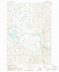
1985 Map of Montour
USGS Topo · Published 1986About this map
Sweet Valley and the surrounding canyonlands of the Payette River define this Idaho landscape in the mid-1980s. The settlement of Sweet sits at the junction of Squaw Creek and the valley floor, while further downstream, the river widens into the Black Canyon Reservoir. The geography is characterized by deep tributary canyons and distinct topographic landmarks such as Regan Butte and South Mountain.
Find a feature on this map
27 named features on this map. Tap any name to fly to it.
Don’t see what you’re looking for? This feature index may not catch every label — zoom into the map to look around manually.
Map Details
Editions of this 1985 Montour Map
This is the sole edition of this map. No revisions or reprints were ever made.
Other maps of this area

1892 · Boise
USGS Topo · 1:125,000

1894 · Squaw Creek
USGS Topo · 1:125,000

1897 · Boise
USGS Topo · 1:125,000

1953 · Banks
USGS Topo · 1:62,500

1953 · Montour
USGS Topo · 1:62,500

1955 · Baker
USGS Topo · 1:250,000

1955 · Boise
USGS Topo · 1:250,000

1957 · Cartwright Canyon
USGS Topo · 1:24,000

1957 · Horseshoe Bend
USGS Topo · 1:24,000

1958 · Boise
USGS Topo · 1:250,000