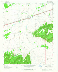
1964 Map of Montoya
USGS Topo · Published 1967About this map
The high plains of eastern New Mexico intersect with the corridor of Route 66 and the Interstate 40 project on this mid-1960s survey. At its center is Montoya, a settlement defined by the confluence of the Southern Pacific and the Chicago Rock Island and Pacific railroads. This intersection made it a critical stop for steam-era water and logistics, as evidenced by the local Juana de Darca Ch and nearby Cem. The landscape is dominated by the dramatic escarpment of Palomas Mesa and prominent landmarks like Captivas Peak, which tower over the drainage systems of Arroyo de las Palomas and Bull Canyon. Numerous named windmills, such as Headquarters Windmill and Aires Windmill, illustrate the pastoral economy's reliance on groundwater across this arid terrain near the Guadalupe and Quay county line.
Find a feature on this map
29 named features on this map. Tap any name to fly to it.
Don’t see what you’re looking for? This feature index may not catch every label — zoom into the map to look around manually.
Map Details
Editions of this 1964 Montoya Map
This is the sole edition of this map. No revisions or reprints were ever made.
Other maps of this area

1930 · Tucumcari
USGS Topo · 1:125,000

1954 · Santa Fe
USGS Topo · 1:250,000

1954 · Fort Sumner
USGS Topo · 1:250,000

1954 · Tucumcari
USGS Topo · 1:250,000

1954 · Clovis
USGS Topo · 1:250,000

1958 · Fort Sumner
USGS Topo · 1:250,000

1958 · Santa Fe
USGS Topo · 1:250,000

1958 · Clovis
USGS Topo · 1:250,000

1958 · Tucumcari
USGS Topo · 1:250,000

1964 · Muniz Canyon
USGS Topo · 1:24,000