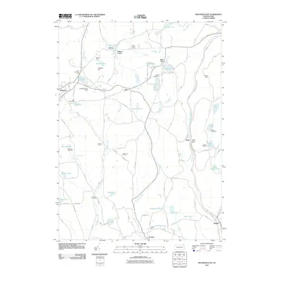
2010 Map of Montrose East
USGS Topo · Published 2010About this map
Montrose serves as the primary hub in this corner of Susquehanna County, where the landscape is defined by its glacial lakes and narrow valleys. This 2010 survey illustrates a rural infrastructure centered on the intersections of historic corridors like Turnpike Rd and Post Pond Rd. Small residential clusters and family-named landmarks such as Williams Corner and Watrous Corners remain anchored to the topography, while numerous cemeteries like Newton Hill Cemetery and Rosengrants Cemetery provide critical data points for genealogists tracking local families. The drainage patterns of Meshoppen Creek and Martins Creek organize the terrain, supporting a network of small dams and reservoirs including Lake Montrose and Heart Lake. Notable for its lake-side communities and agricultural hamlets like Kingsley and Brooklyn, the map documents the persistent settlement patterns of northeastern Pennsylvania's plateau.
Find a feature on this map
66 named features on this map. Tap any name to fly to it.
Don’t see what you’re looking for? This feature index may not catch every label — zoom into the map to look around manually.
Map Details
Editions of this 2010 Montrose East Map
This is the sole edition of this map. No revisions or reprints were ever made.
Other maps of this area

1892 · Dundaff
USGS Topo · 1:62,500

1932 · Susquehanna
USGS Topo · 1:62,500

1935 · Susquehanna
USGS Topo · 1:62,500

1943 · Montrose
USGS Topo · 1:62,500

1945 · Montrose
USGS Topo · 1:62,500

1946 · Tunkhannock
USGS Topo · 1:62,500

1946 · Springville
USGS Topo · 1:24,000

1946 · Hop Bottom
USGS Topo · 1:24,000
1946 · Lenoxville
USGS Topo · 1:24,000

1947 · Hopbottom
USGS Topo · 1:24,000