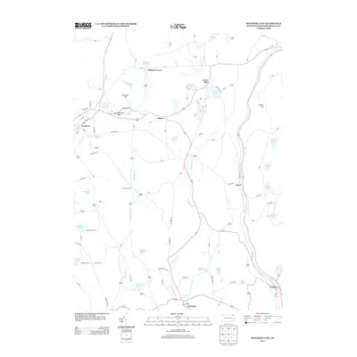
2013 Map of Montrose East
USGS Topo · Published 2013About this map
Montrose sits at the western edge of this landscape, serving as a hub for a network of country roads like Turnpike Rd and High School Rd that weave through the glacial terrain of Susquehanna County. The area is defined by numerous water bodies, ranging from the prominent Heart Lake and Lake Montrose to smaller basins such as Warriner Pond, Williams Pond, and the Pa-468 Reservoir near Brooklyn. The hydrology here is complex, with Snake Cr and Meshoppen Cr draining the northern and western uplands, while Martins Cr follows a deep valley in the east through Alford and Kingsley. This 2013 topographic study reveals a rural settlement pattern where crossroads like Watrous Corners and Williams Corner maintain their identity alongside elevated landmarks such as Birchard Hill and Poplar Hill.
Find a feature on this map
71 named features on this map. Tap any name to fly to it.
Don’t see what you’re looking for? This feature index may not catch every label — zoom into the map to look around manually.
Map Details
Editions of this 2013 Montrose East Map
This is the sole edition of this map. No revisions or reprints were ever made.
Other maps of this area

1892 · Dundaff
USGS Topo · 1:62,500

1932 · Susquehanna
USGS Topo · 1:62,500

1935 · Susquehanna
USGS Topo · 1:62,500

1943 · Montrose
USGS Topo · 1:62,500

1945 · Montrose
USGS Topo · 1:62,500

1946 · Tunkhannock
USGS Topo · 1:62,500

1946 · Springville
USGS Topo · 1:24,000

1946 · Hop Bottom
USGS Topo · 1:24,000
1946 · Lenoxville
USGS Topo · 1:24,000

1947 · Hopbottom
USGS Topo · 1:24,000