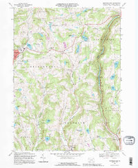
1992 Map of Montrose East
USGS Topo · Published 1995About this map
Montrose serves as the focal point of this Susquehanna County landscape, where the town's residential footprint meets the waters of Lake Montrose. The surrounding terrain is defined by a dense network of upland ponds and intersecting creeks, including the headwaters of Snake Creek and Martins Creek. This 1990s revision reflects a mix of institutional growth and long-standing rural identifiers, from the Montrose Area High Sch and nearby Hosp to the isolated clusters at Tiffany and Watrous Corners. The economy of the land is visible in the numerous Quarries dotting the hillsides, particularly near the Old Railroad Grade and the village of Kingsley. For those tracing local families, the map provides precise locations for the Newton Hill Cem and Williams Pond Cem, as well as the secluded East Bridgewater Ch.
Find a feature on this map
58 named features on this map. Tap any name to fly to it.
Don’t see what you’re looking for? This feature index may not catch every label — zoom into the map to look around manually.
Map Details
Editions of this 1992 Montrose East Map
This is the sole edition of this map. No revisions or reprints were ever made.
Other maps of this area

1892 · Dundaff
USGS Topo · 1:62,500

1932 · Susquehanna
USGS Topo · 1:62,500

1935 · Susquehanna
USGS Topo · 1:62,500

1943 · Montrose
USGS Topo · 1:62,500

1945 · Montrose
USGS Topo · 1:62,500

1946 · Tunkhannock
USGS Topo · 1:62,500

1946 · Springville
USGS Topo · 1:24,000

1946 · Hop Bottom
USGS Topo · 1:24,000
1946 · Lenoxville
USGS Topo · 1:24,000

1947 · Hopbottom
USGS Topo · 1:24,000