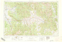
1956 Map of Montrose
USGS Topo · Published 1964About this map
Gunnison River drainage and the surrounding high mountain plateaus define this mid-century topographic study, capturing a period when new water infrastructure began transforming the Western Slope. The introduction of the Blue Mesa Reservoir and Morrow Point Reservoir stands in contrast to the established mining-era settlements of Gothic, Tincup, and St Elmo. Transportation is anchored by the D & R G W RR and U.S. 50, connecting agricultural hubs like Montrose and Hotchkiss to the high country. From the sheer depths of the Black Canyon of the Gunnison National Monument to the heights of Uncompahgre Peak and Mount Sneffels, the map documents a landscape divided between national forests and the mesa-top ranching communities of Redlands Mesa and Fruitland Mesa.
Find a feature on this map
127 named features on this map. Tap any name to fly to it.
Don’t see what you’re looking for? This feature index may not catch every label — zoom into the map to look around manually.
Map Details
Editions of this 1956 Montrose Map
3 editions found

Other maps of this area

1888 · Crested Butte
USGS Topo · 1:62,500

1888 · Anthracite
USGS Topo · 1:62,500

1889 · Crested Butte
USGS Topo · 1:62,500

1889 · Anthracite
USGS Topo · 1:62,500

1889 · Leadville
USGS Topo · 1:125,000

1891 · Leadville
USGS Topo · 1:125,000

1893 · Anthracite
USGS Topo · 1:62,500

1893 · Crested Butte
USGS Topo · 1:62,500

1893 · Aspen
USGS Topo · 1:62,500

1894 · Anthracite
USGS Topo · 1:62,500