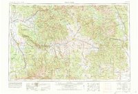
1956 Map of Montrose
USGS Topo · Published 1978About this map
The Uncompahgre Plateau and the high basins of the Gunnison River dominate this 1950s landscape, captured just as major water reclamation projects were transforming the region's geography. The map reveals the early footprint of the Blue Mesa Reservoir and Taylor Park Reservoir, critical components for managing the high-altitude runoff that feeds the Colorado River system. Settlement patterns follow the river valleys and the winding route of the Denver & Rio Grande Western RR, which connects mountain outposts like Tincup and St Elmo to the agricultural hubs of Montrose and Delta.
Find a feature on this map
215 named features on this map. Tap any name to fly to it.
Don’t see what you’re looking for? This feature index may not catch every label — zoom into the map to look around manually.
Map Details
Editions of this 1956 Montrose Map
3 editions found

Other maps of this area

1888 · Crested Butte
USGS Topo · 1:62,500

1888 · Anthracite
USGS Topo · 1:62,500

1889 · Crested Butte
USGS Topo · 1:62,500

1889 · Anthracite
USGS Topo · 1:62,500

1889 · Leadville
USGS Topo · 1:125,000

1891 · Leadville
USGS Topo · 1:125,000

1893 · Anthracite
USGS Topo · 1:62,500

1893 · Crested Butte
USGS Topo · 1:62,500

1893 · Aspen
USGS Topo · 1:62,500

1894 · Anthracite
USGS Topo · 1:62,500