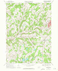
1967 Map of Montrose West
USGS Topo · Published 1971About this map
Montrose sits as a significant hub in the northeast corner of this 1967 survey, where local commerce and civic life are marked by the presence of a Library and the Holy Name of Mary Cem. The landscape is defined by the winding course of the Wyalusing Creek East Branch and the Lehigh Valley railroad line, which served the industrial and agricultural needs of settlements like South Montrose and Fairdale.
Find a feature on this map
39 named features on this map. Tap any name to fly to it.
Don’t see what you’re looking for? This feature index may not catch every label — zoom into the map to look around manually.
Map Details
Editions of this 1967 Montrose West Map
This is the sole edition of this map. No revisions or reprints were ever made.
Other maps of this area

1943 · Montrose
USGS Topo · 1:62,500

1943 · Le Raysville
USGS Topo · 1:62,500

1945 · Montrose
USGS Topo · 1:62,500

1945 · Le Raysville
USGS Topo · 1:62,500

1945 · Meshoppen
USGS Topo · 1:62,500

1945 · Auburn Center
USGS Topo · 1:24,000

1946 · Tunkhannock
USGS Topo · 1:62,500

1946 · Springville
USGS Topo · 1:24,000

1946 · Hop Bottom
USGS Topo · 1:24,000

1947 · Hopbottom
USGS Topo · 1:24,000