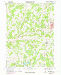
1968 Map of Montrose West
USGS Topo · Published 1978About this map
Montrose serves as the focal point of this Susquehanna County landscape, where the Corporate Boundary defines the transition from a concentrated town center to the surrounding dairy and agricultural lands. The regional economy is evidenced by the numerous Quarries dotting the hillsides and the presence of the Lehigh Valley railroad line, which skirts the eastern edge through South Montrose. These industrial footprints coexist with the area's natural hydrology, including Big Elk Lake and Little Elk Lake to the south, and the branching headwaters of East Branch Wyalusing Creek. For genealogists, the map preserves the locations of several community burial grounds such as Prospect Hill Cem and Fair Hill Cem, along with vanished or rural hubs like Snows Mill and Bumps Corners. The inclusion of Zaverton Airfield and modern utilities like the northern Pipeline reflects the mid-century infrastructure growth in this part of Pennsylvania.
Find a feature on this map
45 named features on this map. Tap any name to fly to it.
Don’t see what you’re looking for? This feature index may not catch every label — zoom into the map to look around manually.
Map Details
Editions of this 1968 Montrose West Map
This is the sole edition of this map. No revisions or reprints were ever made.
Other maps of this area

1943 · Montrose
USGS Topo · 1:62,500

1943 · Le Raysville
USGS Topo · 1:62,500

1945 · Montrose
USGS Topo · 1:62,500

1945 · Le Raysville
USGS Topo · 1:62,500

1945 · Meshoppen
USGS Topo · 1:62,500

1945 · Auburn Center
USGS Topo · 1:24,000

1946 · Tunkhannock
USGS Topo · 1:62,500

1946 · Springville
USGS Topo · 1:24,000

1946 · Hop Bottom
USGS Topo · 1:24,000

1947 · Hopbottom
USGS Topo · 1:24,000