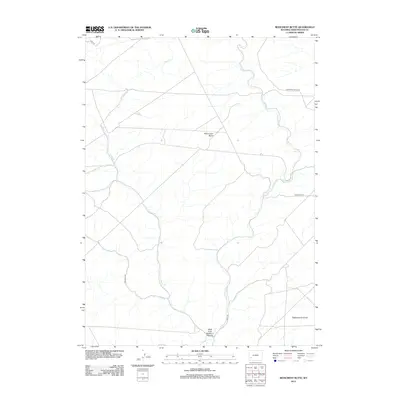
2012 Map of Monument Butte
USGS Topo · Published 2012About this map
Monument Butte rises as a central landmark in this portion of the high Wyoming desert, situated within a network of drainage systems and rural transit routes. The landscape is defined by the winding course of Slate Cr, which carves through the terrain from the northwest. A series of remote access roads, including Steed Rd and Colorado Rd, provide a framework for navigating this isolated region of Sweetwater County. In the southern reaches of the quadrangle, the topography drops into the West Fork Buckhorn Canyon, while the prominent Eighteenmile Knoll stands near the eastern boundary. This 2012 survey illustrates the modern configuration of the range, highlighting the intersections of named routes like Twelvemile Rd and Hunt Rd as they move across the sagebrush-covered flats and high points of the basin.
Find a feature on this map
9 named features on this map. Tap any name to fly to it.
Don’t see what you’re looking for? This feature index may not catch every label — zoom into the map to look around manually.
Map Details
Editions of this 2012 Monument Butte Map
This is the sole edition of this map. No revisions or reprints were ever made.
Other maps of this area

1955 · Preston
USGS Topo · 1:250,000

1955 · Lander
USGS Topo · 1:250,000

1958 · Lander
USGS Topo · 1:250,000

1958 · Preston
USGS Topo · 1:250,000

1961 · Lander
USGS Topo · 1:250,000

1962 · Preston
USGS Topo · 1:250,000
1968 · Twelvemile Sink
USGS Topo · 1:24,000
1968 · Monument Butte NE
USGS Topo · 1:24,000

1968 · Anderson Canyon
USGS Topo · 1:24,000

1968 · Fontenelle Reservoir SE
USGS Topo · 1:24,000