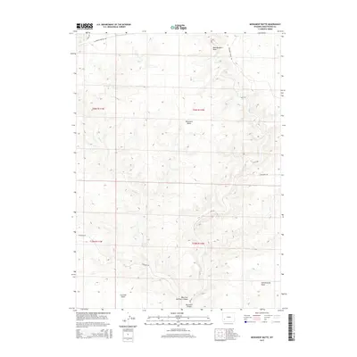
2015 Map of Monument Butte
USGS Topo · Published 2015About this map
The California-Oregon Trl cuts across the northern reaches of this Sweetwater County landscape, preserving the path of westward expansion. This 2015 survey reveals an arid, undulating terrain defined by complex drainages and high points such as Monument Butte and Eighteenmile Knoll. The waterway of Slate Cr meanders through the western sections, while the southeast is marked by the rugged topography of Buckhorn Canyon and the West Fork Buckhorn Canyon.
Find a feature on this map
17 named features on this map. Tap any name to fly to it.
Don’t see what you’re looking for? This feature index may not catch every label — zoom into the map to look around manually.
Map Details
Editions of this 2015 Monument Butte Map
This is the sole edition of this map. No revisions or reprints were ever made.
Other maps of this area

1955 · Preston
USGS Topo · 1:250,000

1955 · Lander
USGS Topo · 1:250,000

1958 · Lander
USGS Topo · 1:250,000

1958 · Preston
USGS Topo · 1:250,000

1961 · Lander
USGS Topo · 1:250,000

1962 · Preston
USGS Topo · 1:250,000
1968 · Twelvemile Sink
USGS Topo · 1:24,000
1968 · Monument Butte NE
USGS Topo · 1:24,000

1968 · Anderson Canyon
USGS Topo · 1:24,000

1968 · Fontenelle Reservoir SE
USGS Topo · 1:24,000