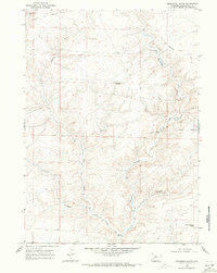
1968 Map of Monument Butte
USGS Topo · Published 1971About this map
The Emigrant Trail (Sublette Cutoff) traces the northern horizon of this high-desert landscape, representing a vital historical shortcut for mid-19th-century travelers. By the late 1960s, the terrain south of the trail had become a network of ranching and resource roads, including the Hunt Road and Colorado Road. The map reveals a reliance on isolated water points in an arid environment, marked by named sources such as Monument Butte Well and Little Colorado Well No 13.
Find a feature on this map
20 named features on this map. Tap any name to fly to it.
Don’t see what you’re looking for? This feature index may not catch every label — zoom into the map to look around manually.
Map Details
Editions of this 1968 Monument Butte Map
This is the sole edition of this map. No revisions or reprints were ever made.
Other maps of this area

1955 · Preston
USGS Topo · 1:250,000

1955 · Lander
USGS Topo · 1:250,000

1958 · Lander
USGS Topo · 1:250,000

1958 · Preston
USGS Topo · 1:250,000

1961 · Lander
USGS Topo · 1:250,000

1962 · Preston
USGS Topo · 1:250,000
1968 · Twelvemile Sink
USGS Topo · 1:24,000
1968 · Monument Butte NE
USGS Topo · 1:24,000

1968 · Anderson Canyon
USGS Topo · 1:24,000

1968 · Fontenelle Reservoir SE
USGS Topo · 1:24,000