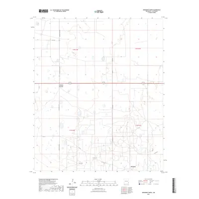
2023 Map of Monument North
USGS Topo · Published 2023About this map
Monument and its surrounding high desert landscape in Lea County appear here in a recent survey that highlights the intersection of transportation and topography. The map area is anchored by the historic water source at Monument Springs, a critical landmark in this arid region of Southeast New Mexico. To the north, the confluence of several thoroughfares at Arkansas Junction creates a central hub for the local road network, including S Arkansas Junction and Squires Rd.
Find a feature on this map
18 named features on this map. Tap any name to fly to it.
Don’t see what you’re looking for? This feature index may not catch every label — zoom into the map to look around manually.
Map Details
Editions of this 2023 Monument North Map
This is the sole edition of this map. No revisions or reprints were ever made.
Other maps of this area

1954 · Hobbs
USGS Topo · 1:250,000

1958 · Hobbs
USGS Topo · 1:250,000

1962 · Lovington
USGS Topo · 1:62,500

1963 · Monument
USGS Topo · 1:62,500

1969 · Humble City
USGS Topo · 1:24,000

1969 · Hobbs SW
USGS Topo · 1:24,000

1969 · Hobbs West
USGS Topo · 1:24,000
1985 · Monument North
USGS Topo · 1:24,000
1985 · Lovington SE
USGS Topo · 1:24,000
1985 · Lovington SW
USGS Topo · 1:24,000