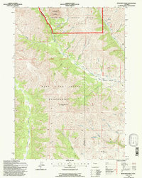
1991 Map of Monument Peak
USGS Topo · Published 1997About this map
The Wind River Indian Reservation meets the high country of the Shoshone National Forest in this survey of the eastern Absaroka Range. The landscape is defined by its drainage systems and high peaks, notably the prominent Washakie Needles and the high point of Monument Peak. A significant landmark is the Muddy Monument Peak Lookout, positioned to monitor the vast timberlands and the transition into the Washakie Wilderness.
Find a feature on this map
23 named features on this map. Tap any name to fly to it.
Don’t see what you’re looking for? This feature index may not catch every label — zoom into the map to look around manually.
Map Details
Editions of this 1991 Monument Peak Map
This is the sole edition of this map. No revisions or reprints were ever made.
Other maps of this area

1904 · Kirwin
USGS Topo · 1:125,000

1906 · Kirwin
USGS Topo · 1:125,000

1955 · Thermopolis
USGS Topo · 1:250,000

1958 · Thermopolis
USGS Topo · 1:250,000

1962 · Thermopolis
USGS Topo · 1:250,000

1967 · Willow Creek
USGS Topo · 1:24,000
1967 · Circle Ridge
USGS Topo · 1:24,000

1967 · Monument Peak
USGS Topo · 1:24,000
1967 · East Fork Basin
USGS Topo · 1:24,000
1967 · Johnson Draw
USGS Topo · 1:24,000