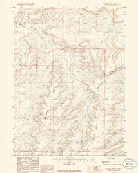
1986 Map of Monument Ridge
USGS Topo · Published 1986About this map
The Continental Divide serpentines through this high-altitude landscape of Sweetwater County, marking the drainage separation between the Atlantic and Pacific watersheds. This 1980s-era study captures a complex system of drainage and relief, where Monument Ridge stands as a central topographic spine. To the north, the headwaters of Rock Cabin Creek and Morrow Creek carve into the terrain, while the area near Parnell indicates a point of interest amidst the high-desert drainages. The map reveals the intricate network of erosional features common to this part of the Red Desert region, including the sheer walls of Box Canyon and the southern reaches of Bush Rim. Cattle trails and unimproved roads trace the paths used for ranching and resource management, providing a clear record of land use before modern intensive development.
Find a feature on this map
13 named features on this map. Tap any name to fly to it.
Don’t see what you’re looking for? This feature index may not catch every label — zoom into the map to look around manually.
Map Details
Editions of this 1986 Monument Ridge Map
This is the sole edition of this map. No revisions or reprints were ever made.
Other maps of this area

1954 · Rock Springs
USGS Topo · 1:250,000

1955 · Lander
USGS Topo · 1:250,000

1958 · Lander
USGS Topo · 1:250,000

1958 · Rock Springs
USGS Topo · 1:250,000

1958 · Essex Mountain
USGS Topo · 1:62,500

1958 · Boars Tusk
USGS Topo · 1:62,500

1958 · Freighter Gap
USGS Topo · 1:62,500

1958 · Superior
USGS Topo · 1:62,500

1961 · Lander
USGS Topo · 1:250,000

1962 · Rock Springs
USGS Topo · 1:250,000