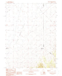
1990 Map of Moody Peak NW
USGS Topo · Published 1990About this map
Little Smoky Valley dominates this 1990 provisional study, marking a remote intersection of three Nevada counties. The landscape is defined by its isolation and the surveyor's focus on essential water and infrastructure in an arid basin. The map records the exact meeting point of several political lines, including the junction of Eureka, White Pine, and Nye counties. Evidence of local industry and transit is sparse but present, noted through a Gravel Pit and a network of 4wd tracks that cut across the alluvial fans. This survey is particularly useful for understanding the historic Indefinite Boundary and the locations of vital water sources like the isolated Well that served this high-desert region during the late twentieth century.
Find a feature on this map
8 named features on this map. Tap any name to fly to it.
Don’t see what you’re looking for? This feature index may not catch every label — zoom into the map to look around manually.
Map Details
Editions of this 1990 Moody Peak NW Map
This is the sole edition of this map. No revisions or reprints were ever made.
Other maps of this area

1926 · Roberts Mountains
USGS Topo · 1:250,000

1929 · Roberts Mountains
USGS Topo · 1:250,000

1953 · Pinto Summit
USGS Topo · 1:62,500

1955 · Millett
USGS Topo · 1:250,000

1956 · Bellevue Peak
USGS Topo · 1:62,500

1956 · Cockalorum Wash
USGS Topo · 1:62,500

1956 · Ely
USGS Topo · 1:250,000

1959 · Ely
USGS Topo · 1:250,000

1959 · Millett
USGS Topo · 1:250,000

1963 · Ely
USGS Topo · 1:250,000