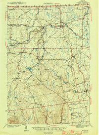
1943 Map of Mooers
USGS Topo · Published 1943About this map
Mooers and the surrounding borderlands of Clinton County sit at a unique international crossroads as of this 1943 survey. The Canada United States boundary is clearly marked, featuring the U S Customs station at a vital northern entry point. The landscape is defined by the branching networks of the English River and the Great Chazy River, which supported early industrial hamlets like Woods Falls and Mooers Forks. These river valleys dictated the path of the Rutland railroad, which facilitated trade and travel across the northern tier of New York.
Find a feature on this map
69 named features on this map. Tap any name to fly to it.
Don’t see what you’re looking for? This feature index may not catch every label — zoom into the map to look around manually.
Map Details
Editions of this 1943 Mooers Map
2 editions found

Other maps of this area

1894 · Plattsburg
USGS Topo · 1:62,500

1895 · Mooers
USGS Topo · 1:62,500

1895 · Rouse Point
USGS Topo · 1:62,500

1899 · Mooers
USGS Topo · 1:62,500

1906 · Plattsburg
USGS Topo · 1:62,500

1907 · Rouse Point
USGS Topo · 1:62,500

1911 · Lyon Mountain
USGS Topo · 1:62,500

1913 · Dannemora
USGS Topo · 1:62,500

1913 · Lyon Mountain
USGS Topo · 1:62,500

1915 · Churubusco
USGS Topo · 1:62,500