
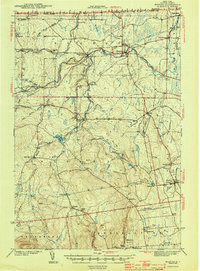
1943 Map of Mooers
USGS Topo · Published 1943About this map
The Great Chazy River and the Rutland RR define the settlement patterns of northern Clinton County in the years following the Great Depression. This landscape, surveyed shortly before the United States entered World War II, shows a network of small dairy and farming hamlets linked by rail and water. Concentrated around Mooers, the map details a rural infrastructure of one-room schoolhouses such as White Sch and School No 8, and small commercial centers like Mooers Forks and Sciota. The international boundary between Canada and the United States runs along the northern edge, where Perry Mills sits just south of the Quebec line.
Find a feature on this map
60 named features on this map. Tap any name to fly to it.
Don’t see what you’re looking for? This feature index may not catch every label — zoom into the map to look around manually.
Map Details
Editions of this 1943 Mooers Map
2 editions found
Other maps of this area

1894 · Plattsburg
USGS Topo · 1:62,500

1895 · Mooers
USGS Topo · 1:62,500

1895 · Rouse Point
USGS Topo · 1:62,500

1899 · Mooers
USGS Topo · 1:62,500

1906 · Plattsburg
USGS Topo · 1:62,500

1907 · Rouse Point
USGS Topo · 1:62,500

1911 · Lyon Mountain
USGS Topo · 1:62,500

1913 · Dannemora
USGS Topo · 1:62,500

1913 · Lyon Mountain
USGS Topo · 1:62,500

1915 · Churubusco
USGS Topo · 1:62,500