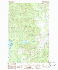
1985 Map of Moon Mountain
USGS Topo · Published 1985About this map
The Colville Indian Reservation landscape is defined by the high ridges and deep valleys of Ferry County, dominated by the peaks of Moon Mountain and Stranger Mtn. In the mid-1980s, the rural community of Meteor and the Cornstalk area reflect a quiet, resource-oriented settlement pattern near the eastern boundary of the reservation. Water management is a critical feature of the terrain, evidenced by the Twin Lakes Ditch and the proximity of Round Lake and the larger North Twin Lake. Along the shorelines, leisure and community hubs appear at Carson Beach, the Hidden Beach Campground, and the Lakeside Grange. The geography moves from the heights of Oregon City Ridge down into the productive Seyler Valley, where Hall Creek and Lynx Creek drain the timbered slopes.
Find a feature on this map
27 named features on this map. Tap any name to fly to it.
Don’t see what you’re looking for? This feature index may not catch every label — zoom into the map to look around manually.
Map Details
Editions of this 1985 Moon Mountain Map
2 editions found
Other maps of this area

1948 · Hunters
USGS Topo · 1:62,500

1948 · Wilmont Creek
USGS Topo · 1:62,500

1950 · Wilmont Creek
USGS Topo · 1:62,500

1950 · Hunters
USGS Topo · 1:62,500

1950 · Inchelium
USGS Topo · 1:62,500

1952 · Twin Lakes
USGS Topo · 1:62,500

1954 · Okanogan
USGS Topo · 1:250,000

1956 · Wilmont Creek
USGS Topo · 1:62,500

1958 · Okanogan
USGS Topo · 1:250,000

1984 · Nespelem
USGS Topo · 1:100,000