
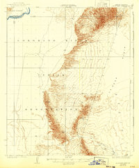
1932 Map of Moon Mtn
USGS Topo · Published 1932About this map
The Colorado River Indian Reservation dominates the landscape in this early 1930s survey, marking a significant tribal boundary along the Arizona-California border. Situated between the Colorado River to the west and the arid expanse of the La Posa Plain to the east, the terrain is defined by the sharp elevations of the Dome Rock Mountains and the distinct peak of Moon Mtn. Hardrock mining activity is evident in the mountain foothills, specifically at the Valenzuela Mine and the Mammoth Mine, suggesting a period of mineral exploration in this desert corridor. The path of Tyson Wash provides a natural drainage route through the basin, illustrating the geographic relationship between the river valley and the high desert interior during the governorship of Geo. W. P. Hunt.
Find a feature on this map
10 named features on this map. Tap any name to fly to it.
Don’t see what you’re looking for? This feature index may not catch every label — zoom into the map to look around manually.
Map Details
Editions of this 1932 Moon Mtn Map
2 editions found
Other maps of this area

1911 · Parker
USGS Topo · 1:125,000

1930 · Linskey
USGS Topo · 1:62,500

1931 · Moon Mtn
USGS Topo · 1:62,500

1933 · Cunningham Mtn
USGS Topo · 1:48,000

1940 · Dome Rock Mts
USGS Topo · 1:62,500

1942 · Blythe
USGS Topo · 1:250,000

1942 · MOON MTN
USGS Topo · 1:62,500

1943 · Parker
USGS Topo · 1:62,500

1943 · Vidal
USGS Topo · 1:62,500

1945 · Big Maria Mtns
USGS Topo · 1:62,500