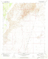
1971 Map of Moon Mtn NE
USGS Topo · Published 1973About this map
Mesquite Mountain dominates the central landscape of this western Arizona quadrangle, creating a stark topographical divide between the lowlands of Parker Valley to the west and the expansive La Posa Plain to the east. The 1971 survey captures the area at a time of early industrial activity and complex land management, evidenced by the prominent Colorado River Indian Reservation Boundary slicing through the terrain. In the western portion of the map, resource extraction is visible through several clusters of Gravel Pits and a solitary Gravel Pit, providing a specific look at the mid-century infrastructure and land use in this desert environment. The map details the transition from high-relief mountain ridges to the broad alluvial plains of the La Posa Plain.
Find a feature on this map
6 named features on this map. Tap any name to fly to it.
Don’t see what you’re looking for? This feature index may not catch every label — zoom into the map to look around manually.
Map Details
Editions of this 1971 Moon Mtn NE Map
This is the sole edition of this map. No revisions or reprints were ever made.
Other maps of this area

1911 · Parker
USGS Topo · 1:125,000

1930 · Linskey
USGS Topo · 1:62,500

1931 · Moon Mtn
USGS Topo · 1:62,500

1932 · Moon Mtn
USGS Topo · 1:62,500

1942 · Blythe
USGS Topo · 1:250,000

1942 · MOON MTN
USGS Topo · 1:62,500

1943 · Parker
USGS Topo · 1:62,500

1949 · Parker
USGS Topo · 1:62,500

1950 · Parker
USGS Topo · 1:62,500

1954 · Salton Sea
USGS Topo · 1:250,000